
Thank you for supporting this site ❤️
Make a donation
Make a donation
Gear up for your next adventure:
As an Amazon Associate, this site earns from qualifying purchases at no extra cost to you.
Walluf topographic map
Click on the map to display elevation.
Thank you for supporting this site ❤️
Make a donation
Make a donation
Gear up for your next adventure:
As an Amazon Associate, this site earns from qualifying purchases at no extra cost to you.
About this map
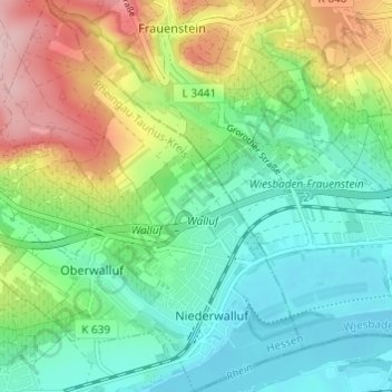
Name: Walluf topographic map, elevation, terrain.
Location: Walluf, Rheingau-Taunus-Kreis, Hesse, 65396, Germany (50.02981 8.12732 50.06881 8.17516)
Average elevation: 492 ft
Minimum elevation: 259 ft
Maximum elevation: 961 ft
Thank you for supporting this site ❤️
Make a donation
Make a donation
Gear up for your next adventure:
As an Amazon Associate, this site earns from qualifying purchases at no extra cost to you.