
Mat topographic map
Click on the map to display elevation.
About this map
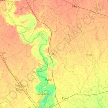
Name: Mat topographic map, elevation, terrain.
Location: Mat, Mathura, Uttar Pradesh, India (27.51630 77.52095 27.96776 77.90995)
Average elevation: 597 ft
Minimum elevation: 531 ft
Maximum elevation: 640 ft
Other topographic maps
Click on a map to view its topography, its elevation and its terrain.
Govardhan
India > Uttar Pradesh > Mathura
Govardhana is located at 27°30′N 77°28′E / 27.5°N 77.47°E / 27.5; 77.47. It has an average elevation of 179 metres (587 feet). Govardhana has been made Tehsil in Mathura District by the Uttar Pradesh government.
Average elevation: 594 ft