Make a donation
Gear up for your next adventure:
As an Amazon Associate, this site earns from qualifying purchases at no extra cost to you.
Argostoli topographic map
Click on the map to display elevation.
Make a donation
Gear up for your next adventure:
As an Amazon Associate, this site earns from qualifying purchases at no extra cost to you.
About this map
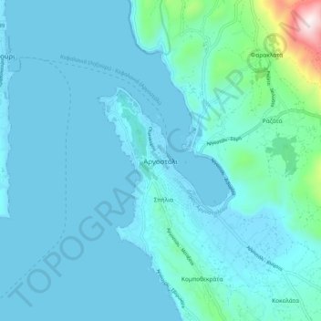
Name: Argostoli topographic map, elevation, terrain.
Average elevation: 259 ft
Minimum elevation: -3 ft
Maximum elevation: 2,769 ft
Make a donation
Gear up for your next adventure:
As an Amazon Associate, this site earns from qualifying purchases at no extra cost to you.
Other topographic maps
Click on a map to view its topography, its elevation and its terrain.
Mount Ainos National Park
Greece > Peloponnese, Western Greece and the Ionian > Kefallonia Regional Unit > Municipal Unit of Elios-Proni
Average elevation: 1,644 ft
Cephalonia
Greece > Peloponnese, Western Greece and the Ionian > Kefallonia Regional Unit
The island's highest mountain is Mount Ainos, with an elevation of 1628 meters; to the west-northwest are the Paliki mountains, where Lixouri is found, with other mountains including Geraneia (Gerania) and Agia Dynati. The top of Mount Ainos is covered with fir trees and is a natural park.
Average elevation: 453 ft
Atheras
Greece > Peloponnese, Western Greece and the Ionian > Kefallonia Regional Unit > Paliki Municipal Unit
Average elevation: 315 ft
Cephalonia
Greece > Peloponnese, Western Greece and the Ionian > Kefallonia Regional Unit
The island's highest mountain is Mount Ainos, with an elevation of 1628 meters; to the west-northwest are the Paliki mountains, where Lixouri is found, with other mountains including Geraneia (Gerania) and Agia Dynati. The top of Mount Ainos is covered with fir trees and is a natural park.
Average elevation: 453 ft
Make a donation
Gear up for your next adventure:
As an Amazon Associate, this site earns from qualifying purchases at no extra cost to you.
