
Utah Olympic Park topographic map
Interactive map
Click on the map to display elevation.
About this map
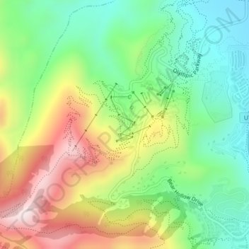
Name: Utah Olympic Park topographic map, elevation, terrain.
Average elevation: 7,113 ft
Minimum elevation: 6,424 ft
Maximum elevation: 8,146 ft
Other topographic maps
Click on a map to view its topography, its elevation and its terrain.
Pitt and Page Hill
Stati Uniti d'America > Utah > Summit County
Pitt and Page Hill, Summit County, Utah, Stati Uniti d'America
Average elevation: 9,551 ft