
Iserloy topographic map
Interactive map
Click on the map to display elevation.
About this map
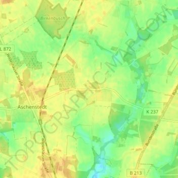
Name: Iserloy topographic map, elevation, terrain.
Average elevation: 128 ft
Minimum elevation: 75 ft
Maximum elevation: 161 ft
Other topographic maps
Click on a map to view its topography, its elevation and its terrain.
Ostrittrum
Deutschland > Niedersachsen > Landkreis Oldenburg > Dötlingen
Ostrittrum, Dötlingen, Landkreis Oldenburg, Niedersachsen, 27801, Deutschland
Average elevation: 79 ft
Voßberg
Deutschland > Niedersachsen > Landkreis Oldenburg > Dötlingen > Voßberg
Voßberg, Dötlingen, Landkreis Oldenburg, Niedersachsen, 27793, Deutschland
Average elevation: 105 ft