
Humphreyville topographic map
Interactive map
Click on the map to display elevation.
About this map
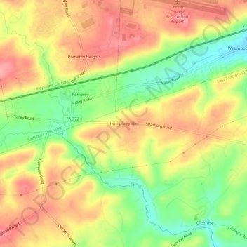
Name: Humphreyville topographic map, elevation, terrain.
Average elevation: 551 ft
Minimum elevation: 367 ft
Maximum elevation: 699 ft
Other topographic maps
Click on a map to view its topography, its elevation and its terrain.
Mortonville
United States > Pennsylvania > Chester County > East Fallowfield Township
Mortonville, East Fallowfield Township, Chester County, Pennsylvania, 19358, United States
Average elevation: 400 ft
Hephzibah
United States > Pennsylvania > Chester County > East Fallowfield Township
Hephzibah, East Fallowfield Township, Chester County, Pennsylvania, 19358, United States
Average elevation: 433 ft
Ercildoun
United States > Pennsylvania > Chester County > East Fallowfield Township
Ercildoun, East Fallowfield Township, Chester County, Pennsylvania, 13920, United States
Average elevation: 489 ft