Geolocate

Milaor topographic map

Click on the map to display elevation.

About this map

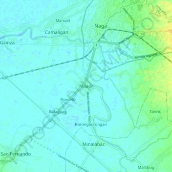
Name: Milaor topographic map, elevation, terrain.

Location: Milaor, Camarines Sur, Bicol Region, 4413, Philippines (13.55588 123.13807 13.63588 123.21807)

Average elevation: 16 ft

Minimum elevation: -10 ft

Maximum elevation: 75 ft

Other topographic maps

Click on a map to view its topography, its elevation and its terrain.

Del Gallego

Philippines > Camarines Sur

Average elevation: 299 ft

Sagñay

Philippines > Camarines Sur

Average elevation: 535 ft

Caramoan

Philippines > Camarines Sur

Average elevation: 138 ft

Gear up for your next adventure:

🚗GPS Dash Cams - Record your scenic drives through mountain passes and canyons
GPS Sports Watch - GPS watch for running, hiking and training
🗺️NatGeo Topo Maps - High-quality waterproof printed topographic maps of US Parks
🎁Geography Themed Gifts - Unique gift ideas for map lovers and geography enthusiasts
Camping Coffee Makers - Enjoy premium coffee at the summit or campsite

As an Amazon Associate, this site earns from qualifying purchases at no extra cost to you.