
Make a donation
Gear up for your next adventure:
As an Amazon Associate, this site earns from qualifying purchases at no extra cost to you.
Yungay topographic map
Click on the map to display elevation.
Make a donation
Gear up for your next adventure:
As an Amazon Associate, this site earns from qualifying purchases at no extra cost to you.
Yungay
Even though the total area of the commune is around 823 km squared, only 3.87 km squared (0.47% of the total territory) has been urbanized: the cities of Yungay (with 9,288 inhabitants as of 2002) and Campanario. In the 2017 census there were 17,787 total inhabitants in the commune. The Yungay Commune is located on the eastern borders of the region, thus it contains parts of the Cordillera of the Andes, where the altitude reaches between 150 and 2000 meters above sea level. Several rivers flow out of the Andes sector and cross the body of the region. Generally, the land is devoted to agricultural purposes, principally the growth of California Pine, wheat, oats, or lentils; or for livestock grazing.
Make a donation
Gear up for your next adventure:
As an Amazon Associate, this site earns from qualifying purchases at no extra cost to you.
About this map
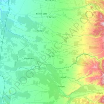
Name: Yungay topographic map, elevation, terrain.
Location: Yungay, Provincia de Diguillín, Ñuble Region, Chile (-37.19718 -72.27985 -36.99854 -71.53989)
Average elevation: 1,204 ft
Minimum elevation: 213 ft
Maximum elevation: 5,390 ft
Make a donation
Gear up for your next adventure:
As an Amazon Associate, this site earns from qualifying purchases at no extra cost to you.
Other topographic maps
Click on a map to view its topography, its elevation and its terrain.
Make a donation
Gear up for your next adventure:
As an Amazon Associate, this site earns from qualifying purchases at no extra cost to you.