
Ronneburg topographic map
Interactive map
Click on the map to display elevation.
About this map
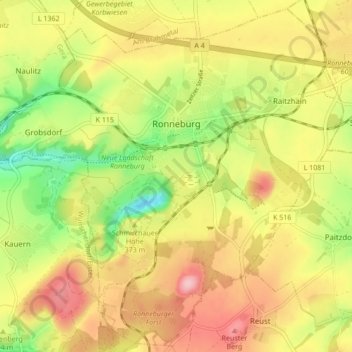
Name: Ronneburg topographic map, elevation, terrain.
Location: Ronneburg, Greiz, Thuringia, Germany (50.82928 12.13596 50.88070 12.22157)
Average elevation: 1,004 ft
Minimum elevation: 719 ft
Maximum elevation: 1,266 ft
Other topographic maps
Click on a map to view its topography, its elevation and its terrain.
Zeulenroda-Triebes
Zeulenroda-Triebes, Greiz, Thuringia, Germany
Average elevation: 1,381 ft