
Jay Peak topographic map
Interactive map
Click on the map to display elevation.
About this map
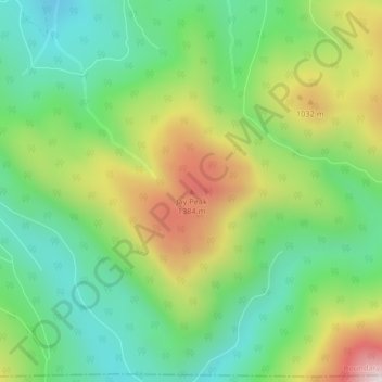
Name: Jay Peak topographic map, elevation, terrain.
Location: Jay Peak, Boundary County, Idaho, USA (48.51405 -116.34302 48.51415 -116.34292)
Average elevation: 3,681 ft
Minimum elevation: 2,933 ft
Maximum elevation: 4,961 ft
Other topographic maps
Click on a map to view its topography, its elevation and its terrain.
Mountain Home
USA > Idaho > Mountain Home
Mountain Home, Elmore County, Idaho, USA
Average elevation: 3,173 ft
American Falls
USA > Idaho > American Falls
American Falls, Power County, Idaho, 83211, USA
Average elevation: 4,413 ft