
Santa Margherita topographic map
Interactive map
Click on the map to display elevation.
About this map
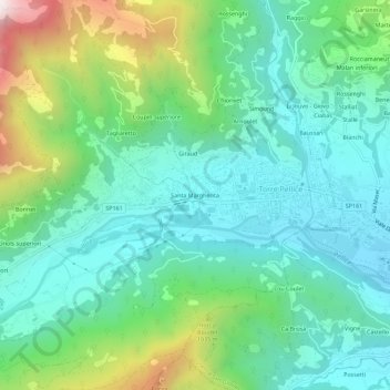
Name: Santa Margherita topographic map, elevation, terrain.
Location: Santa Margherita, Torre Pellice, Torino, Piemonte, 10066, Italia (44.80013 7.19130 44.84013 7.23130)
Average elevation: 2,470 ft
Minimum elevation: 1,558 ft
Maximum elevation: 5,030 ft
Other topographic maps
Click on a map to view its topography, its elevation and its terrain.
Pilon
Italia > Piemonte > Torino > Torre Pellice
Pilon, Torre Pellice, Torino, Piemonte, 10066, Italia
Average elevation: 2,333 ft