
Curahuasi topographic map
Interactive map
Click on the map to display elevation.
About this map
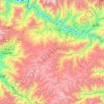
Name: Curahuasi topographic map, elevation, terrain.
Location: Curahuasi, Abancay, Apurímac, 03041, Perú (-13.79021 -72.83086 -13.47827 -72.39879)
Average elevation: 11,493 ft
Minimum elevation: 5,518 ft
Maximum elevation: 17,093 ft
Other topographic maps
Click on a map to view its topography, its elevation and its terrain.
Chinchina
Perú > Apurímac > Justo Apu Sahuaraura
Chinchina, Justo Apu Sahuaraura, Aymaraes, Apurímac, Perú
Average elevation: 11,526 ft
San Juan de Miraflores
Perú > Apurímac > San Juan de Miraflores
San Juan de Miraflores, Andahuaylas, Apurímac, Perú
Average elevation: 11,247 ft
Villa El Salvador
Perú > Apurímac > Villa El Salvador
Villa El Salvador, Chincheros, Apurímac, Perú
Average elevation: 11,955 ft
Montevideo
Perú > Apurímac > Montevideo
Montevideo, Chincheros, Apurímac, Perú
Average elevation: 10,659 ft