
Gersfeld (Rhön) topographic map
Interactive map
Click on the map to display elevation.
About this map
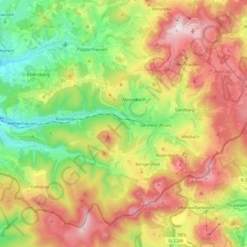
Name: Gersfeld (Rhön) topographic map, elevation, terrain.
Location: Gersfeld (Rhön), Landkreis Fulda, Hessen, 36129, Deutschland (50.39754 9.80086 50.50295 9.99716)
Average elevation: 2,057 ft
Minimum elevation: 1,165 ft
Maximum elevation: 3,127 ft
Gersfeld (Rhön) ist eine Kleinstadt im osthessischen Landkreis Fulda, eingebettet in die Rhön, auf einer Höhe zwischen 371 und 950 m ü. NHN. Als anerkannter Heilklimatischer Kurort und Kneipp-Heilbad ist Gersfeld Ausgangspunkt für Wanderungen durch das Biosphärenreservat Rhön und ein Zentrum des Wintersports. Der Haderswald im Süden ist größtenteils gesperrt, da hier der Nordteil des Truppenübungsplatzes Wildflecken liegt.
Other topographic maps
Click on a map to view its topography, its elevation and its terrain.
Fulda
Deutschland > Hessen > Landkreis Fulda
Fulda, Landkreis Fulda, Hessen, Deutschland
Average elevation: 1,063 ft