
Rothbury topographic map
Interactive map
Click on the map to display elevation.
About this map
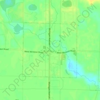
Name: Rothbury topographic map, elevation, terrain.
Average elevation: 689 ft
Minimum elevation: 653 ft
Maximum elevation: 722 ft
Other topographic maps
Click on a map to view its topography, its elevation and its terrain.
Grant Township
United States > Michigan > Oceana County
Grant Township, Oceana County, Michigan, 49452, United States
Average elevation: 719 ft
Hart
United States > Michigan > Oceana County
Hart, Oceana County, Michigan, United States
Average elevation: 705 ft
Greenwood Township
United States > Michigan > Oceana County
Greenwood Township, Oceana County, Michigan, United States
Average elevation: 722 ft
Golden Township
United States > Michigan > Oceana County
Golden Township, Oceana County, Michigan, 49436, United States
Average elevation: 692 ft
Shelby Township
United States > Michigan > Oceana County
Shelby Township, Oceana County, Michigan, 49455, United States
Average elevation: 856 ft