
Santa Elena topographic map
Interactive map
Click on the map to display elevation.
About this map
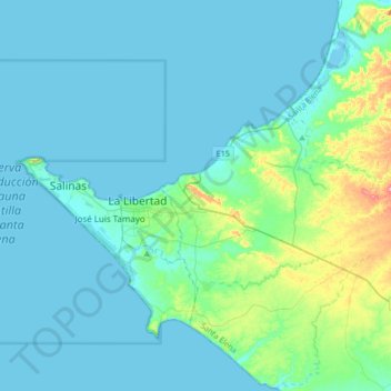
Name: Santa Elena topographic map, elevation, terrain.
Location: Santa Elena, Équateur (-2.32548 -80.88686 -2.10814 -80.55200)
Average elevation: 59 ft
Minimum elevation: -7 ft
Maximum elevation: 446 ft
Other topographic maps
Click on a map to view its topography, its elevation and its terrain.
Santa Elena
Équateur > Santa Elena > Santa Elena
Santa Elena, 240103, Équateur
Average elevation: 59 ft