
Make a donation
Gear up for your next adventure:
As an Amazon Associate, this site earns from qualifying purchases at no extra cost to you.
Dalian City topographic map
Click on the map to display elevation.
Make a donation
Gear up for your next adventure:
As an Amazon Associate, this site earns from qualifying purchases at no extra cost to you.
About this map
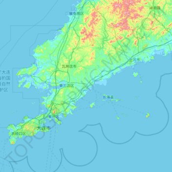
Name: Dalian City topographic map, elevation, terrain.
Location: Dalian City, Liaoning, China (38.57183 120.97190 40.20400 123.51525)
Average elevation: 151 ft
Minimum elevation: -7 ft
Maximum elevation: 3,369 ft
Make a donation
Gear up for your next adventure:
As an Amazon Associate, this site earns from qualifying purchases at no extra cost to you.
Other topographic maps
Click on a map to view its topography, its elevation and its terrain.
Anshan
China > Liaoning > Anshan > Shengli Subdistrict
Local transportation is primarily by bus or taxi. Anshan used to have a single tram line—along Zhonghua Avenue, through the city centre and past Angang main gate—but this has been closed and the tracks removed. Due to the flat topography of the city centre, bicycles are popular. Almost all roads have a…
Average elevation: 259 ft
Anshan
China > Liaoning > Shengli Subdistrict
Local transportation is primarily by bus or taxi. Anshan used to have a single tram line—along Zhonghua Avenue, through the city centre and past Angang main gate—but this has been closed and the tracks removed. Due to the flat topography of the city centre, bicycles are popular. Almost all roads have a…
Average elevation: 259 ft
Make a donation
Gear up for your next adventure:
As an Amazon Associate, this site earns from qualifying purchases at no extra cost to you.