
Make a donation
Gear up for your next adventure:
As an Amazon Associate, this site earns from qualifying purchases at no extra cost to you.
Rexburg topographic map
Click on the map to display elevation.
Make a donation
Gear up for your next adventure:
As an Amazon Associate, this site earns from qualifying purchases at no extra cost to you.
Rexburg
Rexburg is located at 43°49′N 111°47′W / 43.817°N 111.783°W / 43.817; -111.783, at an elevation of 4,865 feet (1,483 m) above sea level.
Make a donation
Gear up for your next adventure:
As an Amazon Associate, this site earns from qualifying purchases at no extra cost to you.
About this map
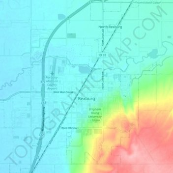
Name: Rexburg topographic map, elevation, terrain.
Location: Rexburg, Madison County, Idaho, 83460, United States (43.79356 -111.83788 43.86297 -111.74794)
Average elevation: 4,934 ft
Minimum elevation: 4,843 ft
Maximum elevation: 5,272 ft
Madison County trails, hiking, mountain biking, running and outdoor activities
Make a donation
Gear up for your next adventure:
As an Amazon Associate, this site earns from qualifying purchases at no extra cost to you.