
Thank you for supporting this site ❤️
Make a donation
Make a donation
Gear up for your next adventure:
As an Amazon Associate, this site earns from qualifying purchases at no extra cost to you.
Oberzent topographic map
Click on the map to display elevation.
Thank you for supporting this site ❤️
Make a donation
Make a donation
Gear up for your next adventure:
As an Amazon Associate, this site earns from qualifying purchases at no extra cost to you.
About this map
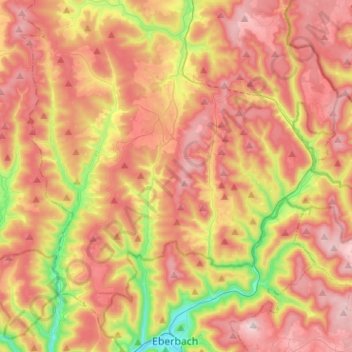
Name: Oberzent topographic map, elevation, terrain.
Location: Oberzent, Odenwaldkreis, Hesse, 64760, Germany (49.47055 8.87295 49.61080 9.12665)
Average elevation: 1,302 ft
Minimum elevation: 407 ft
Maximum elevation: 2,014 ft
Thank you for supporting this site ❤️
Make a donation
Make a donation
Gear up for your next adventure:
As an Amazon Associate, this site earns from qualifying purchases at no extra cost to you.