Geolocate

Tianguá topographic map

Click on the map to display elevation.

About this map

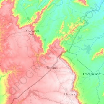
Name: Tianguá topographic map, elevation, terrain.

Location: Tianguá, Região Geográfica Imediata de São Benedito - Ipu - Guaraciaba do Norte - Tianguá, Região Geográfica Intermediária de Sobral, Ceará, Northeast Region, Brazil (-3.90014 -41.30076 -3.41717 -40.82168)

Average elevation: 1,460 ft

Minimum elevation: 197 ft

Maximum elevation: 3,041 ft

Other topographic maps

Click on a map to view its topography, its elevation and its terrain.

Buenos Aries

Brazil > Ceará > Alcântaras

Average elevation: 2,438 ft

Rio Itapagé

Brazil > Ceará > Itapajé

Average elevation: 948 ft

Machuca

Brazil > Ceará > Aquiraz

Average elevation: 62 ft

Gear up for your next adventure:

🔋Solar Power Banks - Keep your GPS and phone charged in remote wilderness areas
📻Weather Alert Radios - Stay informed of storm risks while off-the-grid
🔋Rechargeable Batteries - Power up your outdoor devices
⛑️Personal Locator Beacon - Safety beacon for emergencies
🔥Plasma Lighters - Windproof lighters that work in any weather condition

As an Amazon Associate, this site earns from qualifying purchases at no extra cost to you.