
Make a donation
Gear up for your next adventure:
As an Amazon Associate, this site earns from qualifying purchases at no extra cost to you.
Scheid topographic map
Click on the map to display elevation.
Make a donation
Gear up for your next adventure:
As an Amazon Associate, this site earns from qualifying purchases at no extra cost to you.
Scheid
Scheid is the northwesternmost place in the Vulkaneifel district. It lies roughly 1 km northwest of Hallschlag on a mountain ridge. Its elevation is 593 m above sea level.
Make a donation
Gear up for your next adventure:
As an Amazon Associate, this site earns from qualifying purchases at no extra cost to you.
About this map
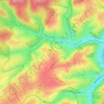
Name: Scheid topographic map, elevation, terrain.
Average elevation: 1,811 ft
Minimum elevation: 1,598 ft
Maximum elevation: 1,991 ft
Make a donation
Gear up for your next adventure:
As an Amazon Associate, this site earns from qualifying purchases at no extra cost to you.
Other topographic maps
Click on a map to view its topography, its elevation and its terrain.
Weinfelder Maar
Germany > Rhineland-Palatinate > Landkreis Vulkaneifel > Schalkenmehren
Average elevation: 1,532 ft