
Mount Zuqualla topographic map
Interactive map
Click on the map to display elevation.
About this map
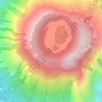
Name: Mount Zuqualla topographic map, elevation, terrain.
Location: Mount Zuqualla, Adama, East Shewa, Oromia Region, Ethiopia (8.53778 38.85260 8.53788 38.85270)
Average elevation: 8,904 ft
Minimum elevation: 7,359 ft
Maximum elevation: 9,852 ft
Other topographic maps
Click on a map to view its topography, its elevation and its terrain.
Adama
Ethiopia > Oromia Region > Adama
Adama, Adama Special Zone, Oromia Region, 36, Ethiopia
Average elevation: 5,489 ft
Awash River
Ethiopia > Oromia Region > Adama
Awash River, Adama, East Shewa, Oromia Region, Ethiopia
Average elevation: 5,236 ft