
Potosí topographic map
Interactive map
Click on the map to display elevation.
About this map
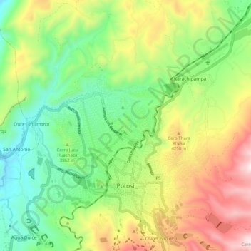
Name: Potosí topographic map, elevation, terrain.
Location: Potosí, Provincia Tomás Frías, Potosí, Bolivien (-19.61045 -65.79983 -19.52319 -65.70060)
Average elevation: 13,143 ft
Minimum elevation: 11,693 ft
Maximum elevation: 15,420 ft
Other topographic maps
Click on a map to view its topography, its elevation and its terrain.