
Make a donation
Gear up for your next adventure:
As an Amazon Associate, this site earns from qualifying purchases at no extra cost to you.
Cartagena topographic map
Click on the map to display elevation.
Make a donation
Gear up for your next adventure:
As an Amazon Associate, this site earns from qualifying purchases at no extra cost to you.
Cartagena
Cartagena's coastal mountains have one of the highest levels of botanical biodiversity on the Iberian Peninsula. A number of surprising Ibero-African species, which are found only in southern Spain (mostly in the provinces of Murcia and Almería) and North Africa. Among these, there stands out Tetraclinis articulata or Sandarac (sabina mora or ciprés de Cartagena —Cartagena cypress in Spanish) native to Morocco, Algeria, Tunisia, Malta, and Cartagena, growing at relatively low altitudes in a hot, dry Mediterranean woodland. Some species are seriously endangered like the siempreviva de Cartagena (Limonium carthaginense), the rabogato del Mar Menor (Sideritis marmironensis), the zamarrilla de Cartagena (Teucrium carthaginense), the manzanilla de Escombreras (Anthemis chrysantha), the garbancillo de Tallante (Astragalus nitidiflorus), the jara de Cartagena (Cistus heterophyllus carthaginensis) and the varica de San José (Narcissus tortifolius).
Make a donation
Gear up for your next adventure:
As an Amazon Associate, this site earns from qualifying purchases at no extra cost to you.
About this map
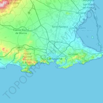
Name: Cartagena topographic map, elevation, terrain.
Average elevation: 233 ft
Minimum elevation: -13 ft
Maximum elevation: 3,409 ft
Make a donation
Gear up for your next adventure:
As an Amazon Associate, this site earns from qualifying purchases at no extra cost to you.
Other topographic maps
Click on a map to view its topography, its elevation and its terrain.
Hacienda del Álamo
Spain > Region of Murcia > Campo de Cartagena y Mar Menor > Fuente Álamo de Murcia
Average elevation: 607 ft
Cabezo de la Plata
Spain > Region of Murcia > Campo de Cartagena y Mar Menor > Cartagena
Average elevation: 279 ft
Monte Sacro
Spain > Region of Murcia > Campo de Cartagena y Mar Menor > Cartagena
Average elevation: 39 ft