
Le Lait topographic map
Interactive map
Click on the map to display elevation.
About this map
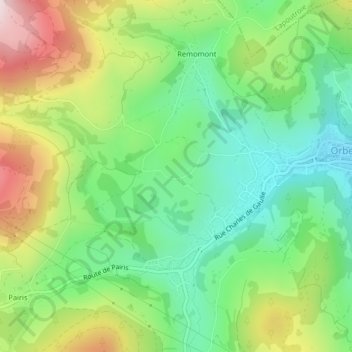
Name: Le Lait topographic map, elevation, terrain.
Average elevation: 2,139 ft
Minimum elevation: 1,572 ft
Maximum elevation: 3,084 ft
Other topographic maps
Click on a map to view its topography, its elevation and its terrain.
Col du Wettstein
Col du Wettstein, Route des Basses Huttes, Gazon l'Hôte, Orbey, Colmar-Ribeauvillé, Haut-Rhin, Grand Est, France métropolitaine, 68370, France
Average elevation: 2,782 ft
Col du Wettstein
Col du Wettstein, Route des Basses Huttes, Gazon l'Hôte, Orbey, Colmar-Ribeauvillé, Haut-Rhin, Grand Est, France métropolitaine, 68370, France
Average elevation: 2,779 ft
Le Noirmont
Le Noirmont, Orbey, Colmar-Ribeauvillé, Haut-Rhin, Grand Est, France métropolitaine, 68370, France
Average elevation: 2,388 ft