Geolocate

Rolling Meadows topographic map

Click on the map to display elevation.

About this map

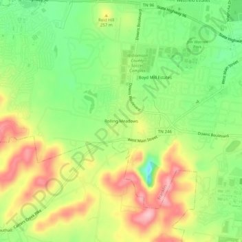
Name: Rolling Meadows topographic map, elevation, terrain.

Location: Rolling Meadows, Franklin, Williamson County, Middle Tennessee, Tennessee, 37064, United States (35.89062 -86.92250 35.93062 -86.88250)

Average elevation: 741 ft

Minimum elevation: 499 ft

Maximum elevation: 1,020 ft

Williamson County trails, hiking, mountain biking, running and outdoor activities

Other topographic maps

Click on a map to view its topography, its elevation and its terrain.

Gear up for your next adventure:

🧭Hiking Compass - Precision compass for reliable navigation in the wilderness
🌄Hiking Binoculars - Compact binoculars for scenic views and trail spotting
🏥Hiking First Aid Kits - Comprehensive medical kits for remote trail injuries
🛡️Bear Spray Outdoor - Protection in bear country hikes
🪄Magnetic Compass - Accurate compass for navigation

As an Amazon Associate, this site earns from qualifying purchases at no extra cost to you.