
Make a donation
Gear up for your next adventure:
As an Amazon Associate, this site earns from qualifying purchases at no extra cost to you.
Saas-Almagell topographic map
Click on the map to display elevation.
Make a donation
Gear up for your next adventure:
As an Amazon Associate, this site earns from qualifying purchases at no extra cost to you.
About this map
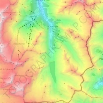
Name: Saas-Almagell topographic map, elevation, terrain.
Location: Saas-Almagell, Visp, Wallis, 3905, Switzerland (45.99590 7.88372 46.12763 8.03472)
Average elevation: 9,285 ft
Minimum elevation: 5,102 ft
Maximum elevation: 14,170 ft
Make a donation
Gear up for your next adventure:
As an Amazon Associate, this site earns from qualifying purchases at no extra cost to you.
Other topographic maps
Click on a map to view its topography, its elevation and its terrain.
Zermatt
Switzerland > Wallis > Visp > Zermatt > Zermatt
It lies at the upper end of Mattertal at an elevation of 1,620 m (5,310 ft), at the foot of Switzerland's highest peaks. It lies about 10 km (6.2 mi) from the over 3,292 m (10,801 ft) high Theodul Pass bordering Italy. Zermatt is the southernmost commune of the German Sprachraum.
Average elevation: 8,100 ft