
Cusworth topographic map
Interactive map
Click on the map to display elevation.
About this map
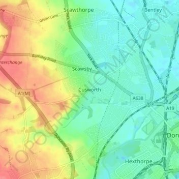
Name: Cusworth topographic map, elevation, terrain.
Average elevation: 82 ft
Minimum elevation: 10 ft
Maximum elevation: 197 ft
Other topographic maps
Click on a map to view its topography, its elevation and its terrain.
Campsall
United Kingdom > England > Doncaster
Campsall, Doncaster, South Yorkshire Mayoral Combined Authority, England, DN6 9AZ, United Kingdom
Average elevation: 79 ft
Thorne
United Kingdom > England > Doncaster
Thorne, Doncaster, Yorkshire and the Humber, England, United Kingdom
Average elevation: 10 ft
Fishlake
United Kingdom > England > Doncaster > Fishlake
Fishlake, Doncaster, South Yorkshire Mayoral Combined Authority, England, United Kingdom
Average elevation: 16 ft