
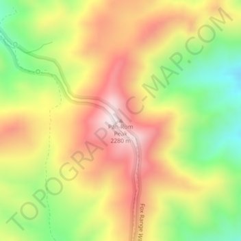
Pah-Rum Peak topographic map
Interactive map
Click on the map to display elevation.
About this map
Name: Pah-Rum Peak topographic map, elevation, terrain.
Average elevation: 6,627 ft
Minimum elevation: 5,600 ft
Maximum elevation: 7,579 ft
Other topographic maps
Click on a map to view its topography, its elevation and its terrain.
Pyramid Lake
Vereinigte Staaten von Amerika > Nevada > Washoe County
Pyramid Lake, Washoe County, Nevada, Vereinigte Staaten von Amerika
Average elevation: 4,613 ft
Steamboat Springs
Vereinigte Staaten von Amerika > Nevada > Washoe County > Steamboat
Steamboat Springs, Steamboat, Washoe County, Nevada, Vereinigte Staaten von Amerika
Average elevation: 4,701 ft
Reno
Vereinigte Staaten von Amerika > Nevada > Washoe County
Reno, Washoe County, Nevada, Vereinigte Staaten von Amerika
Average elevation: 5,413 ft