
Wuqi County topographic map
Interactive map
Click on the map to display elevation.
About this map
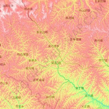
Name: Wuqi County topographic map, elevation, terrain.
Location: Wuqi County, Yan'an, Shaanxi, China (36.55928 107.65051 37.40758 108.54827)
Average elevation: 5,000 ft
Minimum elevation: 3,786 ft
Maximum elevation: 6,234 ft
Wuqi is adjacent to Dingbian County in the northwest, Zhidan County in the southeast, Jingbian County in the northeast, and Huachi County in Gansu Province in the southwest. The county's two main rivers are the Wuding River and the Beiluo River. The region is largely hilly, with the terrain's altitude varying from 1,233 metres (4,045 ft) to 1,809 metres (5,935 ft) in height.