
Woffleben topographic map
Interactive map
Click on the map to display elevation.
About this map
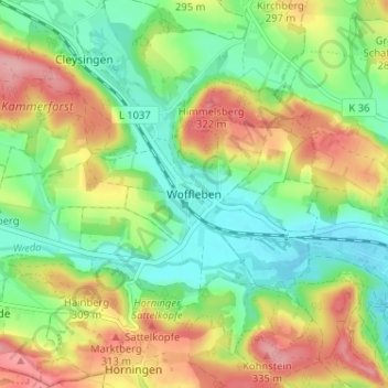
Name: Woffleben topographic map, elevation, terrain.
Average elevation: 850 ft
Minimum elevation: 682 ft
Maximum elevation: 1,089 ft
Other topographic maps
Click on a map to view its topography, its elevation and its terrain.
Sülzhayn
Deutschland > Thüringen > Landkreis Nordhausen > Ellrich
Sülzhayn, Ellrich, Landkreis Nordhausen, Thüringen, Deutschland
Average elevation: 1,194 ft
Gudersleben
Deutschland > Thüringen > Landkreis Nordhausen > Ellrich > Gudersleben
Gudersleben, Ellrich, Landkreis Nordhausen, Thüringen, Deutschland
Average elevation: 889 ft