
Upper Chateaugay Lake Sandbar topographic map
Interactive map
Click on the map to display elevation.
About this map
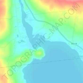
Name: Upper Chateaugay Lake Sandbar topographic map, elevation, terrain.
Average elevation: 1,368 ft
Minimum elevation: 1,299 ft
Maximum elevation: 1,572 ft
Other topographic maps
Click on a map to view its topography, its elevation and its terrain.
Ellenburg Depot
United States > New York > Clinton County > Town of Ellenburg
Ellenburg Depot, Town of Ellenburg, Clinton County, New York, United States
Average elevation: 899 ft
Merrill
United States > New York > Clinton County > Town of Ellenburg
Merrill, Town of Ellenburg, Clinton County, New York, 12955, United States
Average elevation: 1,391 ft
Ellenburg Center
United States > New York > Clinton County > Town of Ellenburg
Ellenburg Center, Town of Ellenburg, Clinton County, New York, 12934, United States
Average elevation: 1,257 ft
Harrigan
United States > New York > Clinton County > Town of Ellenburg
Harrigan, Town of Ellenburg, Clinton County, New York, 12933, United States
Average elevation: 1,667 ft
Lake Roxanne
United States > New York > Clinton County > Town of Ellenburg > Ellenburg Depot
Lake Roxanne, Ellenburg Depot, Town of Ellenburg, Clinton County, New York, United States
Average elevation: 919 ft