
Tamazunchale topographic map
Interactive map
Click on the map to display elevation.
About this map
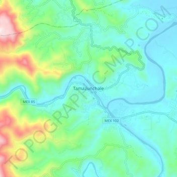
Name: Tamazunchale topographic map, elevation, terrain.
Location: Tamazunchale, San Luis Potosí, México (21.22184 -98.83074 21.30184 -98.75074)
Average elevation: 932 ft
Minimum elevation: 325 ft
Maximum elevation: 2,989 ft
Other topographic maps
Click on a map to view its topography, its elevation and its terrain.
La Cuchilla
México > San Luis Potosí > Tamazunchale
La Cuchilla, Tamazunchale, San Luis Potosí, México
Average elevation: 390 ft