
Make a donation
Gear up for your next adventure:
As an Amazon Associate, this site earns from qualifying purchases at no extra cost to you.
Lemoore topographic map
Click on the map to display elevation.
Make a donation
Gear up for your next adventure:
As an Amazon Associate, this site earns from qualifying purchases at no extra cost to you.
Lemoore
Lemoore (/ləˈmɔːr/ lə-MOR; formerly La Tache and Lee Moore's) is a city in Kings County, California, United States. Lemoore is located 7.5 miles (12 km) west-southwest of Hanford, at an elevation of 230 feet (70 m). It is part of the Hanford-Corcoran Metropolitan Statistical Area (MSA Code 25260). The population was 27,038 at the 2020 Census.
Make a donation
Gear up for your next adventure:
As an Amazon Associate, this site earns from qualifying purchases at no extra cost to you.
About this map
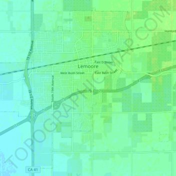
Name: Lemoore topographic map, elevation, terrain.
Location: Lemoore, Kings County, California, 93245, United States (36.26343 -119.84358 36.32195 -119.76404)
Average elevation: 217 ft
Minimum elevation: 200 ft
Maximum elevation: 236 ft
Kings County trails, hiking, mountain biking, running and outdoor activities
Make a donation
Gear up for your next adventure:
As an Amazon Associate, this site earns from qualifying purchases at no extra cost to you.
Other topographic maps
Click on a map to view its topography, its elevation and its terrain.
Armona
United States > California > Kings County > Armona
Armona is a census-designated place (CDP) in Kings County, California, United States. Armona is located 3.5 miles (5.6 km) west-southwest of Hanford, at an elevation of 239 feet (73 m). It is part of the Hanford–Corcoran Metropolitan Statistical Area. The population was 4,156 at the 2010 census. Armona's…
Average elevation: 230 ft
Make a donation
Gear up for your next adventure:
As an Amazon Associate, this site earns from qualifying purchases at no extra cost to you.