
Make a donation
Gear up for your next adventure:
As an Amazon Associate, this site earns from qualifying purchases at no extra cost to you.
Unity topographic map
Click on the map to display elevation.
Make a donation
Gear up for your next adventure:
As an Amazon Associate, this site earns from qualifying purchases at no extra cost to you.
Unity
The highest point in Unity is an unnamed summit along the town's northern boundary, with an elevation of 2,011 feet (613 m) above sea level.
Make a donation
Gear up for your next adventure:
As an Amazon Associate, this site earns from qualifying purchases at no extra cost to you.
About this map
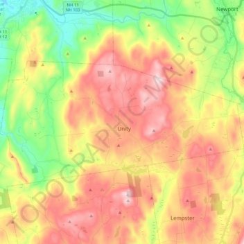
Name: Unity topographic map, elevation, terrain.
Location: Unity, Sullivan County, New Hampshire, United States (43.25986 -72.36173 43.33374 -72.15994)
Average elevation: 1,214 ft
Minimum elevation: 456 ft
Maximum elevation: 1,969 ft
Sullivan County trails, hiking, mountain biking, running and outdoor activities
Make a donation
Gear up for your next adventure:
As an Amazon Associate, this site earns from qualifying purchases at no extra cost to you.
Other topographic maps
Click on a map to view its topography, its elevation and its terrain.
Green Mountain
United States > New Hampshire > Sullivan County > Claremont
Average elevation: 1,463 ft
Eastman
United States > New Hampshire > Sullivan County > Grantham > Eastman
Average elevation: 1,138 ft
Make a donation
Gear up for your next adventure:
As an Amazon Associate, this site earns from qualifying purchases at no extra cost to you.
Mill Hollow
United States > New Hampshire > Sullivan County > Plainfield > Mill Hollow
Average elevation: 1,027 ft