
Río Los Cuartos topographic map
Interactive map
Click on the map to display elevation.
About this map
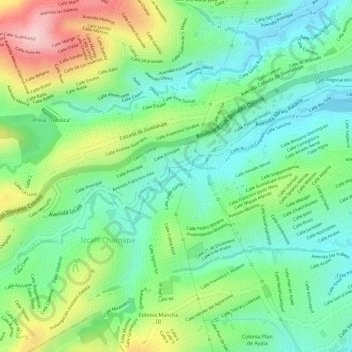
Name: Río Los Cuartos topographic map, elevation, terrain.
Average elevation: 7,825 ft
Minimum elevation: 7,552 ft
Maximum elevation: 8,297 ft
Other topographic maps
Click on a map to view its topography, its elevation and its terrain.
Parque Naucalli
México > Estado de México > Naucalpan de Juárez > Naucalpan de Juárez
Parque Naucalli, Naucalpan de Juárez, Estado de México, México
Average elevation: 7,493 ft