
Carta Valley topographic map
Interactive map
Click on the map to display elevation.
About this map
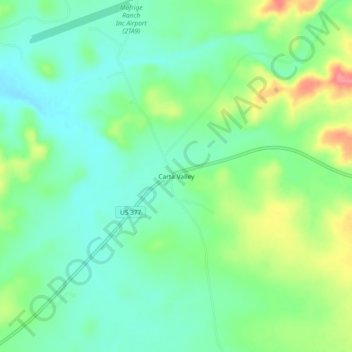
Name: Carta Valley topographic map, elevation, terrain.
Location: Carta Valley, Edwards County, Texas, United States (29.77355 -100.69482 29.81355 -100.65482)
Average elevation: 1,880 ft
Minimum elevation: 1,798 ft
Maximum elevation: 2,047 ft
Other topographic maps
Click on a map to view its topography, its elevation and its terrain.
Rocksprings
United States > Texas > Edwards County > Rocksprings
Rocksprings, Edwards County, Texas, 78880, United States
Average elevation: 2,359 ft
Rocksprings
United States > Texas > Edwards County
Rocksprings, Edwards County, Texas, United States
Average elevation: 2,388 ft