
Attingal topographic map
Interactive map
Click on the map to display elevation.
About this map
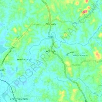
Name: Attingal topographic map, elevation, terrain.
Average elevation: 82 ft
Minimum elevation: 7 ft
Maximum elevation: 367 ft
Other topographic maps
Click on a map to view its topography, its elevation and its terrain.
Kilimanoor
India > Kerala > Chirayinkeezhu > Kilimanoor
Kilimanoor, Chirayinkeezhu, Thiruvananthapuram, Kerala, 695600, India
Average elevation: 194 ft
Chirayinkeezhu
India > Kerala > Chirayinkeezhu
Chirayinkeezhu, Thiruvananthapuram, Kerala, 695309, India
Average elevation: 36 ft
Alamcode
India > Kerala > Chirayinkeezhu
Alamcode, Chirayinkeezhu, Thiruvananthapuram District, Kerala, 695102, India
Average elevation: 95 ft