Geolocate

Sharon topographic map

Click on the map to display elevation.

About this map

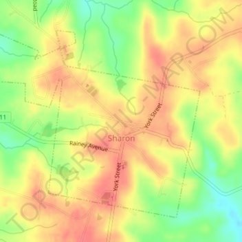
Name: Sharon topographic map, elevation, terrain.

Location: Sharon, York County, South Carolina, United States (34.94207 -81.36059 34.96364 -81.33022)

Average elevation: 600 ft

Minimum elevation: 482 ft

Maximum elevation: 676 ft

Other topographic maps

Click on a map to view its topography, its elevation and its terrain.

Lake Wylie

United States > South Carolina > York County

Average elevation: 617 ft

Blairsville

United States > South Carolina > York County

Average elevation: 577 ft

Pineview

United States > South Carolina > York County > York

Average elevation: 712 ft

Gear up for your next adventure:

🔋Solar Power Banks - Keep your GPS and phone charged in remote wilderness areas
🦺Reflective Outdoor Gear - Safety gear for low‑light conditions
🧴Hand Sanitizer - Keep hands clean while hiking
🔥Plasma Lighters - Windproof lighters that work in any weather condition
👓Polarized Sunglasses - Outdoor sunglasses for glare reduction

As an Amazon Associate, this site earns from qualifying purchases at no extra cost to you.