
Sakarya topographic map
Interactive map
Click on the map to display elevation.
About this map
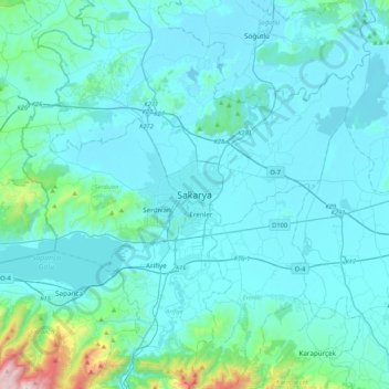
Name: Sakarya topographic map, elevation, terrain.
Location: Sakarya, Adapazarı, Sakarya, Région de Marmara, 54000, Turquie (40.61263 30.24386 40.93263 30.56386)
Average elevation: 381 ft
Minimum elevation: 36 ft
Maximum elevation: 4,026 ft
Other topographic maps
Click on a map to view its topography, its elevation and its terrain.