
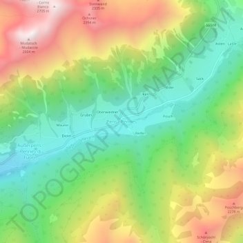
Pens - Pennes topographic map
Interactive map
Click on the map to display elevation.
About this map
Name: Pens - Pennes topographic map, elevation, terrain.
Average elevation: 6,070 ft
Minimum elevation: 4,462 ft
Maximum elevation: 8,406 ft
Other topographic maps
Click on a map to view its topography, its elevation and its terrain.
Durnholz - Valdurna
Italie > Trentin-Haut-Adige > Haut-Adige > Sarntal - Sarentino
Durnholz - Valdurna, Sarntal - Sarentino, Salten-Schlern - Salto-Sciliar, Haut-Adige, Trentin-Haut-Adige, Italie
Average elevation: 6,237 ft
Timpflersäge
Italie > Trentin-Haut-Adige > Haut-Adige > Sarntal - Sarentino > Astfeld - Campolasta
Timpflersäge, Astfeld - Campolasta, Sarntal - Sarentino, Salten-Schlern - Salto-Sciliar, Haut-Adige, Trentin-Haut-Adige, 39058, Italie
Average elevation: 4,524 ft
Wegmann
Italie > Trentin-Haut-Adige > Haut-Adige > Sarntal - Sarentino > Durnholz - Valdurna > Wegmann
Wegmann, Durnholz - Valdurna, Sarntal - Sarentino, Salten-Schlern - Salto-Sciliar, Haut-Adige, Trentin-Haut-Adige, Italie
Average elevation: 6,125 ft