
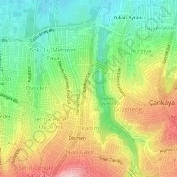
İlkadım Mahallesi topographic map
Interactive map
Click on the map to display elevation.
About this map
Name: İlkadım Mahallesi topographic map, elevation, terrain.
Average elevation: 3,340 ft
Minimum elevation: 3,041 ft
Maximum elevation: 3,727 ft
Other topographic maps
Click on a map to view its topography, its elevation and its terrain.
Beytepe Mahallesi
Beytepe Mahallesi, Ankara, Çankaya, Ankara, Central Anatolia Region, Turkey
Average elevation: 3,691 ft
Ayrancı Mahallesi
Ayrancı Mahallesi, Ankara, Çankaya, Ankara, Central Anatolia Region, Turkey
Average elevation: 3,215 ft