Make a donation
Gear up for your next adventure:
As an Amazon Associate, this site earns from qualifying purchases at no extra cost to you.
Pancas topographic map
Click on the map to display elevation.
Make a donation
Gear up for your next adventure:
As an Amazon Associate, this site earns from qualifying purchases at no extra cost to you.
About this map
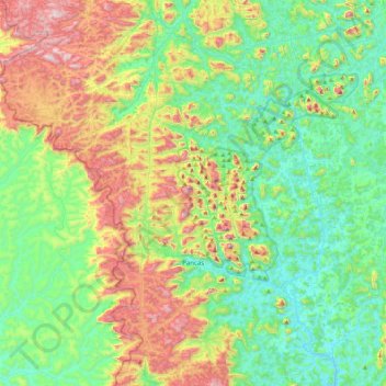
Name: Pancas topographic map, elevation, terrain.
Average elevation: 1,129 ft
Minimum elevation: 246 ft
Maximum elevation: 3,081 ft
Make a donation
Gear up for your next adventure:
As an Amazon Associate, this site earns from qualifying purchases at no extra cost to you.
Other topographic maps
Click on a map to view its topography, its elevation and its terrain.
Pico da Bandeira
Brazil > Espírito Santo > Ibitirama
Pico da Bandeira, or Bandeira Peak (Portuguese for Flag Peak, pronounced [ˈpiku dɐ bɐ̃ˈdejɾɐ]), is the third highest mountain in Brazil, situated on the border of Espírito Santo and Minas Gerais states. It is the highest point in both states. It was considered the highest mountain in Brazil until 1965,…
Average elevation: 8,159 ft
Make a donation
Gear up for your next adventure:
As an Amazon Associate, this site earns from qualifying purchases at no extra cost to you.
Make a donation
Gear up for your next adventure:
As an Amazon Associate, this site earns from qualifying purchases at no extra cost to you.
