
Thank you for supporting this site ❤️
Make a donation
Make a donation
Gear up for your next adventure:
As an Amazon Associate, this site earns from qualifying purchases at no extra cost to you.
Sogeri topographic map
Click on the map to display elevation.
Thank you for supporting this site ❤️
Make a donation
Make a donation
Gear up for your next adventure:
As an Amazon Associate, this site earns from qualifying purchases at no extra cost to you.
About this map
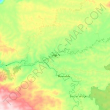
Name: Sogeri topographic map, elevation, terrain.
Location: Sogeri, Central, Papua Region, Papua New Guinea (-9.45761 147.38606 -9.37761 147.46606)
Average elevation: 1,713 ft
Minimum elevation: 1,070 ft
Maximum elevation: 2,493 ft
Thank you for supporting this site ❤️
Make a donation
Make a donation
Gear up for your next adventure:
As an Amazon Associate, this site earns from qualifying purchases at no extra cost to you.