
Make a donation
Gear up for your next adventure:
As an Amazon Associate, this site earns from qualifying purchases at no extra cost to you.
Hohenstein-Ernstthal topographic map
Click on the map to display elevation.
Make a donation
Gear up for your next adventure:
As an Amazon Associate, this site earns from qualifying purchases at no extra cost to you.
Hohenstein-Ernstthal
Hohenstein-Ernsthal is located about 15 kilometres (9.3 mi) west of Chemnitz. The Ore Mountains rise south of the city. The highest point of Hohenstein-Ernstthal is the Pfaffenberg north of the town with an elevation of 479 metres (1,572 ft).
Make a donation
Gear up for your next adventure:
As an Amazon Associate, this site earns from qualifying purchases at no extra cost to you.
About this map
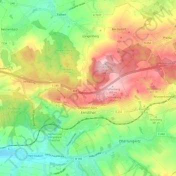
Name: Hohenstein-Ernstthal topographic map, elevation, terrain.
Location: Hohenstein-Ernstthal, Zwickau, Saxony, 09337, Germany (50.78858 12.65435 50.83392 12.76900)
Average elevation: 1,211 ft
Minimum elevation: 909 ft
Maximum elevation: 1,581 ft
Make a donation
Gear up for your next adventure:
As an Amazon Associate, this site earns from qualifying purchases at no extra cost to you.
Other topographic maps
Click on a map to view its topography, its elevation and its terrain.