
Thank you for supporting this site ❤️
Make a donation
Make a donation
Gear up for your next adventure:
As an Amazon Associate, this site earns from qualifying purchases at no extra cost to you.
Limón topographic map
Click on the map to display elevation.
Thank you for supporting this site ❤️
Make a donation
Make a donation
Gear up for your next adventure:
As an Amazon Associate, this site earns from qualifying purchases at no extra cost to you.
Limón
Limón has an area of 59.51 square kilometres (22.98 square miles) and an elevation of three metres (9.8 feet)
Thank you for supporting this site ❤️
Make a donation
Make a donation
Gear up for your next adventure:
As an Amazon Associate, this site earns from qualifying purchases at no extra cost to you.
About this map
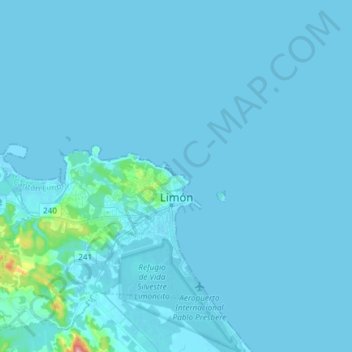
Name: Limón topographic map, elevation, terrain.
Location: Limón, Cantón Limón, Limón Province, 70101, Costa Rica (9.93829 -83.15854 10.06633 -83.00954)
Average elevation: 20 ft
Minimum elevation: -7 ft
Maximum elevation: 587 ft
Thank you for supporting this site ❤️
Make a donation
Make a donation
Gear up for your next adventure:
As an Amazon Associate, this site earns from qualifying purchases at no extra cost to you.