
Engern topographic map
Interactive map
Click on the map to display elevation.
About this map
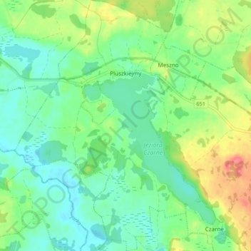
Name: Engern topographic map, elevation, terrain.
Average elevation: 614 ft
Minimum elevation: 541 ft
Maximum elevation: 758 ft
Other topographic maps
Click on a map to view its topography, its elevation and its terrain.
Goldap
Polen > Woiwodschaft Ermland-Masuren > powiat gołdapski
Goldap, gmina Gołdap, powiat gołdapski, Woiwodschaft Ermland-Masuren, 19-500, Polen
Average elevation: 548 ft
Zameczna Góra
Polen > Woiwodschaft Ermland-Masuren > powiat gołdapski > Collnischken
Zameczna Góra, Collnischken, gmina Gołdap, powiat gołdapski, Woiwodschaft Ermland-Masuren, Polen
Average elevation: 751 ft