
Tena topographic map
Interactive map
Click on the map to display elevation.
About this map
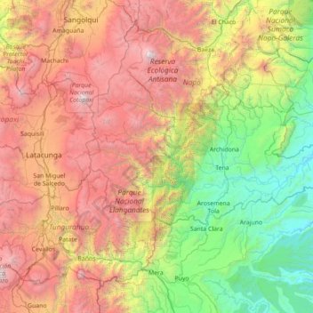
Name: Tena topographic map, elevation, terrain.
Location: Tena, Napo, Équateur (-1.19352 -78.42726 -0.69421 -77.02697)
Average elevation: 7,543 ft
Minimum elevation: 1,020 ft
Maximum elevation: 18,983 ft
Other topographic maps
Click on a map to view its topography, its elevation and its terrain.
Nevado Antisana
Nevado Antisana, Cuyuja, Cantón Quijos, Napo, Équateur
Average elevation: 15,804 ft