
Арский район topographic map
Interactive map
Click on the map to display elevation.
About this map
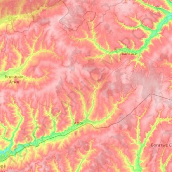
Name: Арский район topographic map, elevation, terrain.
Location: Арский район, Tatarstan, Föderationskreis Wolga, Russland (55.91020 49.50106 56.53721 50.30046)
Average elevation: 505 ft
Minimum elevation: 223 ft
Maximum elevation: 679 ft
Other topographic maps
Click on a map to view its topography, its elevation and its terrain.
Kuibyschewer Stausee
Russland > Tatarstan > Краснослободское сельское поселение
Kuibyschewer Stausee, Краснослободское сельское поселение, Спасский район, Tatarstan, Föderationskreis Wolga, Russland
Average elevation: 374 ft
Nischnekamsker Stausee
Russland > Tatarstan > Малошильнинское сельское поселение
Nischnekamsker Stausee, Малошильнинское сельское поселение, Тукаевский район, Tatarstan, Föderationskreis Wolga, Russland
Average elevation: 423 ft