
Borgholz topographic map
Interactive map
Click on the map to display elevation.
About this map
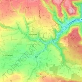
Name: Borgholz topographic map, elevation, terrain.
Average elevation: 791 ft
Minimum elevation: 509 ft
Maximum elevation: 1,089 ft
Other topographic maps
Click on a map to view its topography, its elevation and its terrain.
Natzungen
Deutschland > Nordrhein-Westfalen > Borgentreich
Natzungen, Borgentreich, Kreis Höxter, Regierungsbezirk Detmold, Nordrhein-Westfalen, Deutschland
Average elevation: 807 ft