Geolocate

Pinehurst topographic map

Click on the map to display elevation.

About this map
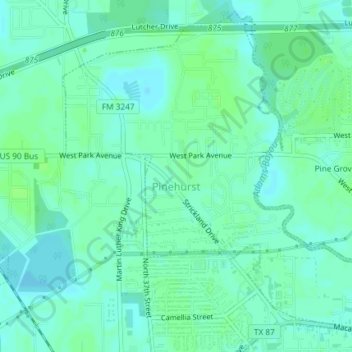
Name: Pinehurst topographic map, elevation, terrain.

Location: Pinehurst, Orange County, Texas, United States (30.09367 -93.78644 30.12250 -93.74962)

Average elevation: 16 ft

Minimum elevation: 3 ft

Maximum elevation: 30 ft

Orange County trails, hiking, mountain biking, running and outdoor activities

Other topographic maps

Click on a map to view its topography, its elevation and its terrain.
Toledo Bend

United States > Texas > Orange County

Average elevation: 13 ft

Connell

United States > Texas > Orange County

Average elevation: 16 ft

Reese

United States > Texas > Orange County

Average elevation: 23 ft

Cove

United States > Texas > Orange County > Orange

Average elevation: 10 ft

Lemonville

United States > Texas > Orange County

Average elevation: 23 ft

Doc Brown

United States > Texas > Orange County > West Orange > Doc Brown

Average elevation: 16 ft

Brownwood

United States > Texas > Orange County > Orange

Average elevation: 13 ft

Gear up for your next adventure:

🦶Carbon Trekking Poles - Reduce knee impact on steep descents with ultra-light poles
🪶Paracord Bracelet - Survival bracelet with built‑in tools
😴Insulated Sleeping Pads - Compact and warm pads for high-elevation camping
🪑Portable Camp Table - Compact table for campsite meals
🧼Biodegradable Camping Soap - Eco‑friendly soap for outdoor hygiene

As an Amazon Associate, this site earns from qualifying purchases at no extra cost to you.